|
|
|
 |
|
|
|
|
|
|
|
New Cemetery
|
|
The top of Jervis Road opens out into Apton Road, the delightful Providence Cottage (built 1864) standing alongside the entrance gates of New Cemetery. Scott Road starts beyond the small roundabout, with the aptly named Cemetery Road to the left. This long, tree-lined road divides the old cemetery (named New Cemetery) and the 'new' cemetery, both occupying large areas of land and both the result of dramatic increases (and decreases) in town population – albeit in different centuries.
Population growth and high death rates had become a problem countrywide in the early 1800s, and by 1850 many city churchyards were over-full. They were also exclusively Anglican, but more importantly were suspected of being harbourers of contamination and a danger to public hygiene. This alone forced many churchyards to close and brought about the Metropolitan Interment Act of 1850, allowing the provision of publicly funded cemeteries in London. Cremation wasn't an option at that time.
In rural areas many parish churches were accommodating the dead by extending their churchyards into neighbouring fields, but there were obviously limits to this practice. Bishop's Stortford had two parish churchyards at that time – St Michael's and All Saints – and two much smaller graveyards for Independents – the Baptist and Congregational chapels. But burial space was still at a premium, and many Independents had to be buried at St Michael's or in profit-making private cemeteries.
The solution came in 1853 with an extension to the Metropolitan Interment Act, allowing local authorities, countrywide, to purchase land for use as a cemetery. The following year St Michael's churchwardens received a letter from the Home Secretary Lord Palmerston, informing them that all burials within parish churches would cease with immediate effect, and after 1 June 1855 in the parish churchyards and in the burial grounds of the Baptist and Congregational chapels.
As a result of this a burial ground had to be found and on 22 June 1854 a Burial Board, consisting of nine members, was formed. A subsequent meeting of the Vestry authorised the Burial Board to purchase land in Apton Fields and, at a cost of no more than £5,000, construct a cemetery and build the necessary chapels. The Vestry also sanctioned the borrowing of the money and charged the future poor rates for its repayment. Within a year New Cemetery was opened for both Anglican and Independent burials.
|
|
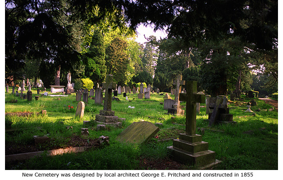
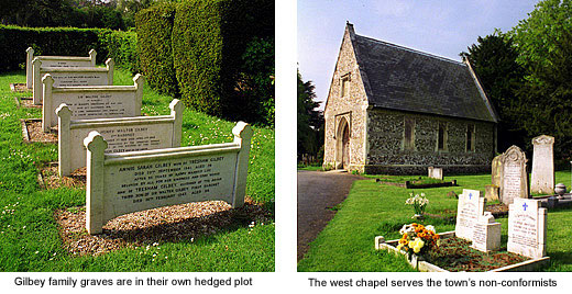
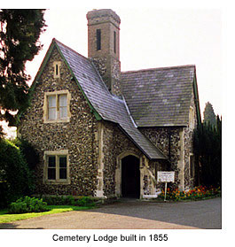 Laid out in a serene and natural setting of pine trees and woodland covering approximately 8 acres, New Cemetery, completed in 1855, was designed by local architect George E. Pritchard (See Guide 5). He was also responsible for the Lodge House and the two mortuary chapels flanking the cemetery grounds, each constructed of flint and mortar. This method of building had largely been abandoned at that time, but Pritchard was renowned for not conforming to fashion. Although identical in appearance, the west chapel serves the Nonconformist churches and the east chapel serves the Anglican Church. The Lodge House was originally lived in, but between 1979 and 2000 was home to the Bishop’s Stortford History Society Museum, now combined with the Rhodes Museum at South Road under the new name, Bishop's Stortford Museum (See Guide 13). Laid out in a serene and natural setting of pine trees and woodland covering approximately 8 acres, New Cemetery, completed in 1855, was designed by local architect George E. Pritchard (See Guide 5). He was also responsible for the Lodge House and the two mortuary chapels flanking the cemetery grounds, each constructed of flint and mortar. This method of building had largely been abandoned at that time, but Pritchard was renowned for not conforming to fashion. Although identical in appearance, the west chapel serves the Nonconformist churches and the east chapel serves the Anglican Church. The Lodge House was originally lived in, but between 1979 and 2000 was home to the Bishop’s Stortford History Society Museum, now combined with the Rhodes Museum at South Road under the new name, Bishop's Stortford Museum (See Guide 13).
The cemetery’s centrepiece is the large burial plot of the Gilbeys, celebrated benefactors of the town in the 19th and early 20th century (See Guide 2). Five white memorial stones encompassed by a well kept hedge, indicate the last resting place of Sir Walter Gilbey, his wife and other family members.
Creation of the newer cemetery on the opposite side of Cemetery Road began shortly before the Second World War on the former site of allotment gardens. And among the very first burials here was that of three German airmen whose plane crashed in Bishop's Stortford on 16 October 1940. Their bodies were later removed and interred in a German military cemetery, but since that time no other burials have been permitted where they were originally laid to rest. The site, near to the roadside hedge, remains a prominent gap between gravestones.
In September 1944, new rules by the Cemetery Committee concerning new cemetery land were as follows: Graves not to be mounded, but maintained at surface level; a number plate to be provided at the head of each grave; burials to take place in strict rotation in each of the respective sections, in accorance with a numbered plan; no permanent artificial wreaths enclosed in glass globes or other similar containers to be allowed to be placed on grave spaces. At that time the cemetery was not expected to be in use until 1945/46.
|
|
|
|
 |
|
|
|
Havers estate
|
|
At the end of World War II there was approximately 2,500 dwellings in Bishop’s Stortford, housing a population of about 12,000. This area, known as Thorley Plantation, was mostly open country and woodland but as Bishop's Stortford began to expand in the late 1940s, farmland in this area was requisitioned for development and construction work began on the Havers – the town's first and only large council estate. German prisoners-of-war detained locally were initially detailed to help with the work. The houses served their purpose well for over forty years, but structural faults found in the early 1990s resulted in most being replaced by modern houses.
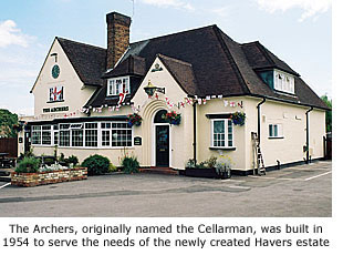
 The creation of Havers estate included the building of a pub in 1954 and a school in 1955. The pub, originally called the Cellarman but later renamed the Archers, thrived in the early years but by the millennium was struggling to stay a viable concern. A brief closure in 2011 was followed by a brief reopening, but owner Greene King finally called time on the pub and it closed for good 30 January 2012. The site will be used for property development. The creation of Havers estate included the building of a pub in 1954 and a school in 1955. The pub, originally called the Cellarman but later renamed the Archers, thrived in the early years but by the millennium was struggling to stay a viable concern. A brief closure in 2011 was followed by a brief reopening, but owner Greene King finally called time on the pub and it closed for good 30 January 2012. The site will be used for property development.
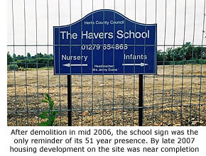
The school, built closeby in Elizabeth Road was named, not surprisingly, The Havers School. This catered adequately for local children in the 1950s and 60s but population growth in the early 70s, mainly due to the development of nearby Thorley, led to the building of a second junior school at Scott Road in 1971. Named The Firs, its title was derived from the broad woodland pathway alongside the school, lined with fir trees. These were planted in the early 1900s to form a private tree-lined avenue leading from Great Hadham Road to Cox's farm at Havers. Houses that form Havers estate mean the route to the farm house was curtailed and now goes only as far as Waytemore Road. Despite the destruction caused to woodland by the the Great Hurricane of 1987, many of the original trees still stand.
 Further development at Thorley throughout the 1990s led to enormous population growth. This was partly compensated for by the building of Manor Fields Primary School at Thorley, but by 2002 it was clear that Havers school could no longer sustain its pupil intake on such a limited site. A decision by school governors to amalgamate with the Firs school was sanctioned and in January 2006 became a reality. With the addition of a new £2.5m wing to accommodate pupils and staff of both schools, the Firs school was renamed Windhill Primary School. Havers school at Elizabeth Road was demolished in 2006 and the site sold for housing development. Further development at Thorley throughout the 1990s led to enormous population growth. This was partly compensated for by the building of Manor Fields Primary School at Thorley, but by 2002 it was clear that Havers school could no longer sustain its pupil intake on such a limited site. A decision by school governors to amalgamate with the Firs school was sanctioned and in January 2006 became a reality. With the addition of a new £2.5m wing to accommodate pupils and staff of both schools, the Firs school was renamed Windhill Primary School. Havers school at Elizabeth Road was demolished in 2006 and the site sold for housing development.
More tree-lined avenues were planned for the area in the early 1900s when Sir Walter Gilbey proposed to build a mansion at the top of Thorley Hill, near to where Havers School was sited. Entrance to the mansion was to be via three avenues: one from the south in Thorley Lane and two from the east – one in London Road, the other in South Road. Lodge houses were built at each of the entrances and gates erected, but all work on the project ceased at the outbreak of war in 1914 and the plan was abandoned altogether when Sir Walter died that same year.
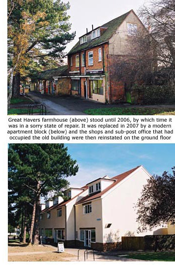 Of the three lodges planned only one still exists; that being No 52 Thorley Lane. Once comanding large wrought-iron entrance gates, it is now flanked by modern houses built in the early 1960s. This lodge house was later owned by the Cox family who farmed the area and lived in a farmhouse at the top of Havers Lane. This, along with an adjacent single-storey out-building, possibly once used as stables, was later utilised to house shops that included a sub-post office and small supermarket. But by 2006 these building were in such a sorry state of repair they were demolished and replaced by a modern apartment block. Shop owners and the sub-post office were then reinstated. Of the three lodges planned only one still exists; that being No 52 Thorley Lane. Once comanding large wrought-iron entrance gates, it is now flanked by modern houses built in the early 1960s. This lodge house was later owned by the Cox family who farmed the area and lived in a farmhouse at the top of Havers Lane. This, along with an adjacent single-storey out-building, possibly once used as stables, was later utilised to house shops that included a sub-post office and small supermarket. But by 2006 these building were in such a sorry state of repair they were demolished and replaced by a modern apartment block. Shop owners and the sub-post office were then reinstated.
Another reminder of the past can be found in nearby Norfolk Way where former farm workers' cottages still stand, but Little Havers farm, once situated near the junction of Thorley Hill and Havers Lane, has long since been replaced by modern development.
The second lodge built to control entrance to Gilbey's proposed mansion was sited near the junction of London Road and Thorley Hill, and the third, South Lodge, stood alongside a definitive pathway in South Road.
|
|
|
|
[ BACK TO TOP ] |
|
|
|
|
|
|
|
|
|