|
|
|
 |
|
|
|
 |
|
Guide map includes satellite image of this area |
|
River Stort - Stort Navigation
|
|
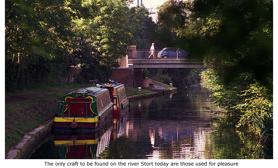
Not until the 16th century did the river flowing through Bishop’s Stortford finally acquire a title – map makers of that period, Saxton & Camden, deciding it should take its name from the town and be called the River Stort.
From its source in Langley Hills, near Clavering in Essex, the river meanders wildly through picturesque countryside before reaching the town; then continues a further 13 1/4 miles through Hertfordshire to Feildes Weir (near Rye House, Hoddesdon) where it falls into the River Lea. Today, the river gives not the slightest indication of its former history or of the constant activity that once surrounded it.
Almost 2000 years ago the invading Romans built a settlement close to its banks on the Meads, but it was the Saxon fording point further south, around which the town eventually grew up. When the Normans arrived in the 11th century they built a castle to guard the busy river crossing and then utilised its course as a defensive moat around their fortress.
 For over 900 years the river supported the townspeople by driving the wheels of its water mills, but when the river was in flood, as it often was, it caused untold damage and misery to those same inhabitants. Not until the town’s malting industry came under threat was the river’s full potential realised and then engineered to become its industrial saviour. For over 900 years the river supported the townspeople by driving the wheels of its water mills, but when the river was in flood, as it often was, it caused untold damage and misery to those same inhabitants. Not until the town’s malting industry came under threat was the river’s full potential realised and then engineered to become its industrial saviour.
In the 16th century the town was a prime supplier of malt to the London breweries – barley grain being turned into malt and then transported by carts to the city. But those same carts caused untold damage to the highways, making them virtually impassable in winter. In order to preserve the roads a ruling was made in 1602, declaring that all malt was to be transported by packhorses between the months of October and March (See Guide 12).
This ruling, combined with strong competition from the nearby malting towns of Hertford and Ware, was catastrophic for Bishop’s Stortford’s malting industry and economic problems endured for many years. The town of Ware, especially, had the advantage of being able to transport its malt to London by the navigable River Lea, something Bishop’s Stortford couldn’t do because the river Stort was far from navigable. Much of its length was shallow and meandering, and for the most part little more than a stream.
It was Thomas Adderley (1707–1774), landlord of The Crown Inn at Hockerill, who finally realised the river’s great potential and it was he and his supporters who gained an Act of Parliament in 1759 to make the river navigable from Rye House to the town mill. Unfortunately, the scheme fell at the first hurdle through lack of finance and was temporarily abandoned.
|
|
|
|
The scheme then came to the attention of George Jackson, who, along with Charles Dingley and William Masterman sat as Commissioners for a new Act that received Royal Assent on 30 April 1766. SEE DETAILS AT FOOT OF THIS PAGE
This time enough finance was raised, and with Jackson as principle shareholder; Thomas Yeoman (1700–1781) as chief engineer, and William Glyn & Son as contractors, work began on canalisation on 24 September that same year.
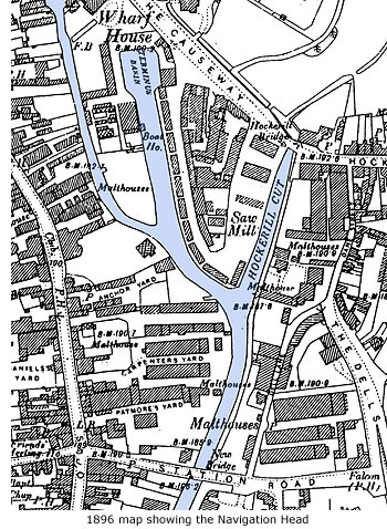 Apart from being dredged, widened and, in places, re-routed and straightened out by gangs of navvies, 15 wooden locks had to be constructed between Bishop’s Stortford and Rye House and three terminus basins were built at the town’s Navigation head. The work was finally completed in 1769 at a cost of £100,000. Apart from being dredged, widened and, in places, re-routed and straightened out by gangs of navvies, 15 wooden locks had to be constructed between Bishop’s Stortford and Rye House and three terminus basins were built at the town’s Navigation head. The work was finally completed in 1769 at a cost of £100,000.
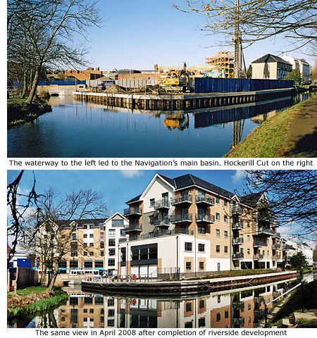
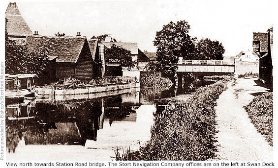
At the northern end of Riverside the river divides into two waterways; the right-hand one, called Hockerill Cut, being the only terminus basin to survive virtually intact. It was here, on 24 October 1769, that the very first barges to journey from London arrived amid unbelievable celebrations (See Guide 8 - Hockerill Cut).
The waterway to the left was the original course of the Stort and formed the entrance to the largest terminus basin, sited approximately where the old multi-storey car park and town library once stood. This is now beneath the new Causeway development. During town redevelopment in the early 1970s the river at this point was dammed at much the same point as it is now.
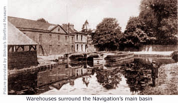
Built around the terminus basin were warehouses, and backing onto it was the garden of Wharf House – George Jackson’s home that stood in Causeway. Between 1920 and 1962 Wharf House became headquarters of Bishop’s Stortford Urban District Council but, in line with town redevelopment, was demolished in 1973. The third and smallest basin was constructed behind the former town mill in Bridge Street, linked to the main waterway by a subsidiary canal. This was also filled in at the time of redevelopment in the 70s.
The Navigation almost certainly saved the town’s malting industry, but the new form of transportation proved to be a slow process. Apart from the 15 locks that barges had to queue at and negotiate, they also had to tarry the tide when the River Thames was reached. Then, after dispensing their cargo of malted barley, the barges would be loaded with grain, timber or coal for the return journey – a round trip that could take up to three weeks.
The long, flat Stort barges, some almost 70ft in length and drawing about two feet of water, carried vast quantities of grain and malt weighing up to 60 tons and sometimes needed two horses to pull them along the towpath. No records exist of early tolls but it is known that in 1791, 19,000 sacks of flour and 97,000 quarters of malt were carried – the equivalent of 7,275 tons or 180 barge-loads of 40 tons. These barges were also used to take away malt dust from the huge roasting kilns and bring in lime and manure for the town.
However, although the town’s malting industry once again prospered and sufficient money was taken in tolls, the Navigation wasn’t an unqualified success financially. In 1812 Sir George Jackson (by this time Sir George Duckett, Baronet ) said that the first twenty years had ‘not been an advantageous concern’.
|
|
 But Sir George was undeterred and in 1811 and 1812 made two attempts to extend the Stort Navigation to Cambridge and beyond, via the River Cam. The first attempt failed, but the second succeeded as the London and Cambridge Canal Act, receiving assent on 9 June 1812. Unsurprisingly, financial backing for the estimated £570,000 cost never materialised and the project was dropped. But Sir George was undeterred and in 1811 and 1812 made two attempts to extend the Stort Navigation to Cambridge and beyond, via the River Cam. The first attempt failed, but the second succeeded as the London and Cambridge Canal Act, receiving assent on 9 June 1812. Unsurprisingly, financial backing for the estimated £570,000 cost never materialised and the project was dropped.
When Sir George Duckett died in 1822 his title and the Navigation were inherited by his son, George, but within two years he mortgaged it for £45,000. That same year, to improve trade on the rivers Lea and Stort, he secured an Act to build the Hertford Union Canal between the Regent’s Canal and the Lea Navigation – its purpose being to avoid the semi-tidal part of the Lea and provide a useful link to the Grand Union Canal.
 Opened in 1830, and known as Duckett’s Cut, it never became a success because of the high tolls charged. Duckett was declared bankrupt in 1832 and his interests sold. In 1833 the Stort Navigation – valued at £150,000 with an annual income of £5,000 – was put up for auction along with the Hertford Union Canal, but there were no takers. The waterway then remained in the hands of the Official Receiver for the next twenty-one years, during which time it gradually deteriorated. Opened in 1830, and known as Duckett’s Cut, it never became a success because of the high tolls charged. Duckett was declared bankrupt in 1832 and his interests sold. In 1833 the Stort Navigation – valued at £150,000 with an annual income of £5,000 – was put up for auction along with the Hertford Union Canal, but there were no takers. The waterway then remained in the hands of the Official Receiver for the next twenty-one years, during which time it gradually deteriorated.
A protracted legal battle between Sir George and his creditor, Richard Gurney, for the recovery of his £45,000 lasted 14 years until finally, in 1853, Gurney reluctantly took on the Navigation. At his death the following year the executors of his estate – his own family firm, Gurney & Co – found themselves the unwilling owners of the Navigation.
Periodic approaches were made to the River Lea trustees to see if they would buy it, and also to the Lea Conservancy Board who succeeded the Lea trustees, but they also refused and it was eventually bought in 1873, ‘persuasively’ and reluctantly, by Trueman, Hanbury & Buxton for £15,000. A year later they themselves tried to persuade the Lea Conservancy Board to take it over, but they didn't consider it a viable business proposition and refused.
Truman, Hanbury & Buxton finally wrote off the Navigation when they sold it to a former engineer of the Navigation, John Poole Davis, for £100. But by this time faster transport offered by the railway and the use of cheap imported grain for malting, all combined to make the Navigation completely unprofitable. Davis, who owned it for 9 years, eventually sold it on 22 July 1898 to Sir Walter Gilbey for £500, becoming the only owner of the Navigation to sell it for more than he paid.
Gilbey, always a benevolent man, kept the Navigation open for the next seven years purely for the benefit of the town, but by 1900 even his vast resources could no longer afford to sustain it. He then entered into protracted negotiations with the Lea Conservancy Board with a view to sell. In May 1905 he formed the Stort Navigation Company and in July transferred ownership of the river to the company for £5,000.
|
|
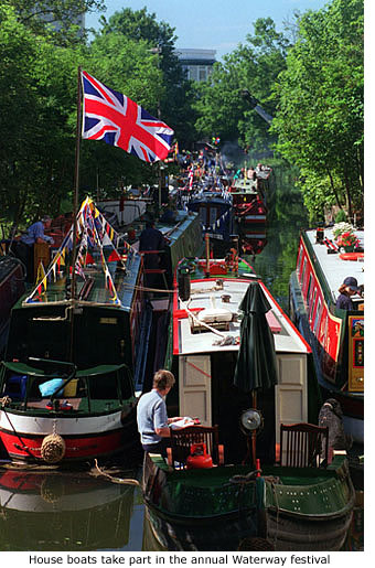 In April 1909, one side of the Brick Cistern Lock at Roydon suddenly collapsed, trapping all but one of the Stort barges above the lock. Thankfully, the Lea Conservancy Board agreed to rebuild it and the canal re-opened in November that same year. Gilbey and his directors then offered the Navigation to the Conservancy Board for nothing, and on 8 September 1911 they paid a nominal sum of 5 shillings (25p) for ownership. In April 1909, one side of the Brick Cistern Lock at Roydon suddenly collapsed, trapping all but one of the Stort barges above the lock. Thankfully, the Lea Conservancy Board agreed to rebuild it and the canal re-opened in November that same year. Gilbey and his directors then offered the Navigation to the Conservancy Board for nothing, and on 8 September 1911 they paid a nominal sum of 5 shillings (25p) for ownership.
Work to improve the Navigation began in 1912 by dredging it throughout and reconstructing all of the wooden locks in concrete, but the First World War (1914–18) intervened and it remained unused until the work was completed after the war. The final cost of dredging and reconstruction was £54,000 and the official re-opening took place on 4 July 1924, the ceremony attended by Henry Gosling MP Minister of Transport. It was, however, a far less spectacular occasion than had occurred at the Navigation’s first opening in 1769, the brief celebrations concluding with nothing more than a lunch for dignitaries at the George Hotel.
Special steel lighters were then built to carry cargo, but this was mainly timber destined for Hughes timber yard at Hockerill Cut. By 1945 trade on the Navigation had ceased altogether and in 1948 all canals were nationalised. Control of the River Stort passed to the British Transport Commission, and when this was disbanded in 1962 it came under the control of the British Waterways Board. MORE PICTURES
|
|
|
|
Stort River
|
|
32 George II. Cap. 42, Royal Assent 23rd March, 1759.
6 George III. Cap. 78, Royal Assent 30th April, 1766.
The first act of parliament relating to this river is entitled, 'An Act for making the River Stort navigable, in the counties of Hertford and Essex, from the New Bridge, in the town of Bishop Stortford, into the River Lea, near a Place called the Rye, in the county of Hertford,' and appointed certain persons commissioners for carrying into effect the provisions of the act'.
In 1766 a second act was passed, entitled, 'An Act for making and continuing navigable the River Stort, in the counties of Hertford and Essex;' which states 'that in consequence of the difficulty experienced by the commissioners appointed under the first act, in raising money for carrying into effect the purposes therein stated, no progress had been made in effecting the said navigation; but that Charles Dingley, George Jackson and William Masterman, Esquires, had undertaken to make and continue navigable the said river, provided an act of parliament could be obtained authorizing them to do so, and to collect certain tolls and rates thereon; the act, therefore, empowers them to complete this undertaking, and to collect the following:'
TONNAGE RATES.
For Wheat, Rye, Beans or Peas.......................................................... 0s 6d per Quarter.
For Malt or Oats.................................................................................. 0s 4d ditto.
For Barley, or any other Sort of Grain not before enumerated............ 0s 5d ditto.
For Meal or Flour (Five Bushels to a Sack)........................................... 0s 4d per Sack.
For Coal, Culm or Cinders.................................................................... 2s 6d per Chaldron.
For Lime............................................................................................... 2s 6d ditto.
For Oil-cakes, Malt-dust, Pigeon Dung or other Manure of any Kind.... 1s 6d per Ton.
For Goods, Wares or Merchandize not before enumerated................. 2s 6d ditto.
And so in proportion for any less Quantity.
Boats returning with a back Lading of Oil-cake, Malt-dust, Pigeon Dung or any other Kind of Manure, which have passed up or down the River immediately before, and paid the Tolls or Rates on their Cargoes, shall be exempted from Tonnage Rate on such Manure.
The tolls, rates and duties on this navigation to be exempted from all taxes and rates whatsoever.
Lords of manors and owners of land on this navigation may build warehouses; and on their refusing to do so, the undertakers may build them. Five years are allowed to the undertakers to complete the navigation.
The part of the river made navigable under authority of these acts, is about ten miles in length, in a southerly and westerly course. It joins the Lea Navigation about a mile and a half from Hoddesden, thus affording a means for the conveyance of corn, malt and other agricultural produce to London.
Reference to Stort Navigation tolls is taken from the HTML edition of ‘Priestley’s Navigable Rivers and Canals’. This HTML edition of the book was reproduced from the 1969 facsimile edition of the original book, first published in 1831, and can be found on ‘Jim Shead’s Waterways Information’ website; an encyclopedia of the canals and rivers of England and Wales that includes much historical data provided by Jim.
|
|
|
|
[ BACK TO TOP ] |
|
|
|
|
|
|
|
|
|


 Apart from being dredged, widened and, in places, re-routed and straightened out by gangs of navvies, 15 wooden locks had to be constructed between Bishop’s Stortford and Rye House and three terminus basins were built at the town’s Navigation head. The work was finally completed in 1769 at a cost of £100,000.
 But Sir George was undeterred and in 1811 and 1812 made two attempts to extend the Stort Navigation to Cambridge and beyond, via the River Cam. The first attempt failed, but the second succeeded as the London and Cambridge Canal Act, receiving assent on 9 June 1812. Unsurprisingly, financial backing for the estimated £570,000 cost never materialised and the project was dropped.
 In April 1909, one side of the Brick Cistern Lock at Roydon suddenly collapsed, trapping all but one of the Stort barges above the lock. Thankfully, the Lea Conservancy Board agreed to rebuild it and the canal re-opened in November that same year. Gilbey and his directors then offered the Navigation to the Conservancy Board for nothing, and on 8 September 1911 they paid a nominal sum of 5 shillings (25p) for ownership.