|
|
|
 |
|
|
|
|
|
 |
|
|
|
 |
|
Guide map includes satellite image of this area
|
|
 |
|
In 1880 feelings ran high among some town residents regarding the naming of certain local roads and thoroughfares, though why this should have caused such unrest is somewhat of a mystery. However, to resolve the problem Bishop's Stortford Local Board instituted the changes asked for, and those changes still apply to this day.
They were: Market Place to be renamed Market Square; Ushers Lane to become Apton Road; and North End to revert to its ancient name of Northgate End. The earliest reference to Northgate End, according to the 1938 book The Place Names of Hertfordshire, is 1620. That doesn't mean it was named at that time, only that that was the first written reference to it. Importantly, the request that the name revert to its 'ancient' name suggests a time much earlier than the 17th century.
In fact, the title 'Northgate End' has led some local historians to conclude that a 'gate' of some description was probably in place at this end of North Street in Saxon times, used, perhaps, to allow entry in and out of the settlement. On the face of it this seems plausible, but it also suggests that Bishop's Stortford was a walled town, which it wasn't.
Opposing the 'gate' theory are those who suggest the town's heritage lies not with the Saxons but with the Danes – or Vikings – the one clue to this possibility also being in the name Northgate End. SEE 'Danelaw' AT FOOT OF THIS PAGE
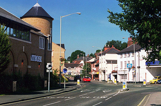
Up until 1970, when the new link road joining Rye Street with the Causeway was built, Northgate End was still the only route into the town centre from Rye Street, going via North Street. The open space outside Carr & Bury's shop at the corner of North Street was the site of a barn in the 18th century, but this was later demolished to make the right-angled turn into North Street easier for stagecoaches to negotiate.
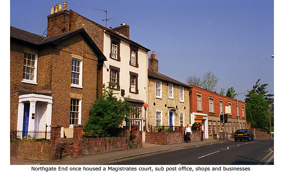
Beyond Half Acres, Northgate End is lined with mostly 19th century buildings, all once residential but now occupied by commercial outlets and offices. No 3 is noticeably smaller than its neighbours but appears to have been built with an overly large chimneystack to compensate – a small arch included halfway up to add stability. The far larger No 7 was a double-fronted house of some standing. On the opposite side of the road is the YMCA, opened in January 1996 and replacing buildings that were formerly part of Hawkes brewery - latterly Ind Coope's depot. MORE PICTURES
|
|
|
|
The Cattle Market
|
|
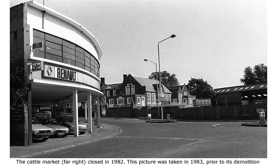
Despite the town centre's severe lack of space in the 18th century, a livestock market gradually grew up in North Street alongside the town’s general market. Cattle would arrive every Thursday in the early hours of the morning, driven here on the hoof from local farms by drovers. These men were a law unto themselves – loud, brutal, and usually drunk whatever time of day it was. To add to the chaos, their routes into and out of town generally meant using local streets, and though the smell and noise of cattle might have been acceptable to 18th century residents, the same could not be said of the Victorians.
After much public protest the problem was finally resolved in 1858 when George E. Sworder, auctioneer, rented land from Hawkes brewery and established a permanent cattle market away from the town centre at Limekiln field. This land, between Northgate End and the river Stort, is now partly taken by the car park opposite Waitrose supermarket.
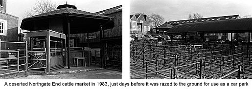
But although the new cattle market thrived on its new site, it was never again as popular or as busy as in its heyday some hundred years before. Messrs G.E. Sworder bought the land outright in 1860, but not until 1929 did the firm get round to modernising the cattle market. By the mid 1900s, however, motorised transport and the railway had created different methods of livestock trading and the cattle market gradually went into decline. Even so, 26,500 head of cattle passed through the market in 1962. A further blow came in 1969 when, as part of the Town Redevelopment Scheme, its size was almost halved to accommodate construction of a new link road between Northgate End and Causeway.
The cattle market's biggest event of the year was always at Christmas time, the 100th Fat Stock Show being held in December 1972. But by this time the market was little more than a sideshow – cattle sales being secondary to a goods and second-hand furniture market held in the redundant cattle sheds. Closure beckoned, and after the last livestock sale was held in December 1982 the site was cleared the following year. The only clue now left of the cattle market’s existence is a small section of the original boundary wall in Northgate End, alongside the car park exit. MORE PICTURES
|
|
|
|
 |
|
|
|
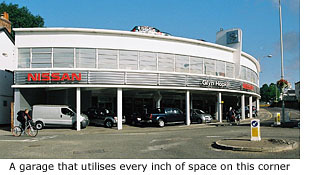
By the early 1930s there were about two million vehicles on the roads of Britain: over 400,000 vans and trucks and one and a half million private cars. To satisfy their insatiable apetite for fuel and repair, garages and filling stations sprang-up everywhere; most purely functional establishments but some, like the garage at the corner of Northgate End, built on a far grander scale.
Replacing a terrace of houses named North Terrace around 1934, this building is unique in that the architect cleverly utilised every inch of available space this small parcel of land allowed him. Following the natural curve of the road the colonnaded ground floor housed a garage complete with petrol pumps and attendant, plus a car showroom. The first floor however, accessed by the steep ramp to the right of the building, housed Prior's scientific instrument factory. Pre 1939 the factory's output was microscopes and magnifying instruments, but during the Second World War the firm greatly helped the war effort by making telescopes and gunsights. Prior's factory continued into the 1950s, finally closing to become a larger car showroom for the garage below.
 In 1998, additional parking space was created with the closure and demolition of G.E. Sworder’s Auction Room that stood alongside the garage. Trading in small antiques, second-hand furniture and house clearance items, it was a regular and popular Thursday venue for locals and traders in search of a bargain. Sworder’s business increased dramatically in the mid 1980s after the closure of Watsons Auction Room in Water Lane, but a lack of space here eventually forced the firm to move to much larger premises at Stansted. In 1998, additional parking space was created with the closure and demolition of G.E. Sworder’s Auction Room that stood alongside the garage. Trading in small antiques, second-hand furniture and house clearance items, it was a regular and popular Thursday venue for locals and traders in search of a bargain. Sworder’s business increased dramatically in the mid 1980s after the closure of Watsons Auction Room in Water Lane, but a lack of space here eventually forced the firm to move to much larger premises at Stansted.
Alongside the auction room had stood Number 15, a large two-storey house also owned by Sworders that once housed an insurance company on the ground floor and private accommodation upstairs. Former Stortfodian Mike Prior, who supplied the above information about the Prior's (not related) factory, was born in the house in 1944. It had no bathroom and was not wired for electricity until 1950/51. The house stood until 2003 when it and the adjoining Rising Sun public house was demolished to make way for another car showroom. In November of 2003, ownership of the garage passed from James Barr to the Glyn Hopkin dealership.
Read Mike Prior's memories of Northgate End
|
|
|
|
 |
|
|
|
 |
|
Sometimes the smallest discoveries are the most fascinating. This message is inscribed on a stone plaque that forms part of the back wall of a barn-like building at the rear of the garage. Many people put their names on boundary walls in the 1800s, presumably to let neighbours know that it was their property. The plaque reads:
|
‘1863 THIS WALL BELONGS TO CORus (perhaps Cornelius) NICHOLLS’
Independent research by local resident, Angela Aldam, revealed further information about Mr Nicholls and I am grateful to her for this contribution.
With regard to the Corn(us) Nicholls mentioned on the plaque at Northgate End, I think Cornus is the chap in the attached census entry, a bricklayer and builder living in Rye street in 1881 (LDS CD-rom). I note that a Cornelius Nicholls married Eliza Palmer on 25 Dec 1840 at St Michael's B/S (extracted entry from the IGI), that there are entries for Cornelius Nicholls as a resident of Church street in 1890 and in Rye Street in 1899 (Kelly's Directories), and that a Cornelius Nicholls died in 1901 aged 82 (FreeBMD). Also the house of a Mr C Nicholls in Church Street was sold by Sworders in 1896 (A2A). |
|
|
|
|
Danelaw
|
|
Like many of the words we use today, 'gate' is of Danish origin, derived from the Danish word 'gat' or 'gata', originally meaning 'road' or 'way'. 'Gate' appears as a suffix in many of the towns and cities of eastern England, the most noteable example of the use of the word being found in the city of York where street names like Monksgate, Micklegate, Swinegate and Newgate still survive from Danish occupation in the 9th and 10th centuries.
At that time York was one of many towns that fell within the kingdoms of Mercia and East Anglia; until, that is, the Danes embarked on a large scale 'invasion' of eastern England in 865 AD.
Northumbria and East Anglia were soon over-run but not until 874, when the Mercian king Burhred was exiled, did the Vikings seize eastern Mercia. Ceolwulf II was allowed to remain as a client king in western Mercia, and to varying degrees the Danish army settled in eastern Mercia where they were possibly joined by peasants migrating from their Scandinavian homeland.
Throughout this time King Alfred's Saxon kingdom of Wessex in the south of England remained unconquered. Many skirmishes and battles took place, but the turning point came when he defeated the Danes at the battle of Edington in 878 and concluded peace with them in the Treaty of Wedmore. The Viking king, Guthrum, was converted to Christianity and most Danes either returned to Northumbria and East Anglia where they settled as farmers, or moved on to other countries.
To further the peace Alfred is said to have negotiated a partition treaty with the Danes in 886, dividing England into two kingdoms. This date has since been questioned by historian David Dumville (1992), who argues that because the Anglo Saxon Chronicle makes no mention of this, the partition agreement was actually drawn up in 878 as part of the Treaty of Wedmore.
Regardless of date, the division of the country was thus: the east (between the rivers Thames and Tees) declared to be Danish territory and comprising of four main regions: Northumbria; areas and boroughs around Lincoln, Nottingham, Derby, Leicester, and Stamford; the SE Midlands, and East Anglia. The southern-most border ran from the Thames estuary as far west as the river Lea, then up the Lea to its source near Leagrave in Bedfordshire. From there the boundary continued onto Bedford and along the river Ouse to Watling Street. The area was under the administrative control of the Danes and became known as 'Danelaw'.
The traditional view, using the river Lea as the Danelaw boundary, is that northern, eastern and some western parts of Hertfordshire were in Danish territory. Older sources state that Bishop's Stortford fell within this boundary, but again David Dumville argues this is now uncertain because Essex at that time was disputed territory. His view is summarised in an article by Ann Williams (Essex Archaeology & History, 1996, pp92–101) in which she says that Essex up to the beginning of the 8th century was part of Mercia, but after 825 it passed to the West Saxons and was included with Sussex and Kent in a subordinate kingdom held by junior members of West Saxon dynasty. After 860 it became part of the kingdom of Wessex.
This means that at the signing of the Wedmore Treaty in 878, Saxons were present in parts of Essex, which actually fell within the Danelaw boundary. Naturally it was precarious territory and they would have been harrassed by Danish armies from East Anglia and any that were present in East Hertfordshire where they were 'legally' entitled to be.
But equally so, the Danes, knowing that Saxons were present in most of western and central Essex, as well as the greater parts of southern and western Hertfordshire, wouldn't have run the risk of being out-flanked. This is possibly why no Danish settlements have ever been recorded in East Hertfordshire and the reason why there are virtually no place names that indicate Danish influence. But, also, the Danes were transient. When they did settle in areas away from their strongholds like Northumbria, north Essex and East Anglia, indigenous inhabitants probably only lived 'briefly' under Danish rule, albeit paying tribute or taxes to a Danish elite.
The greatest difficulty in trying to ascertain areas of Danish settlement in England is the fact that very few written documents or records were kept by them. Much of our information on their social, political and military history actually comes from Saxon documents, more especially the Anglo-Saxon Chronicle, and information on the customary law comes from post-Conquest materials.
But having occupied a large part of England since 865 and, at times, being present in Hertfordshire, we must assume some Danish influence among the Saxon population, particularly in language. There is, therefore, no reason not to suppose Saxons used the word 'gat' or 'gata' to describe a road or route (way) and, locally, thus named the road that led north from their settlement, 'North gat' or 'North gata' i.e. North road, or way.
This argument, however, can be easily counteracted. Firstly, no other road in Bishop's Stortford carries the 'gate' suffix (why isn't there a Southgate?); and secondly, Dr Margaret Gelling OBE, the renowned expert in English place-names, says that Old Norse 'gata' meaning road is hard to distinguish from Old English 'geat', which does mean 'gate' as we know it.
Taking this fact on board, we end up back at square-one and the possibilty that a 'gate', or 'geat' did exist after all. Indeed, if a market of some description was present at that time, a gate could have been in place to establish the town or market boundary for trading and toll purposes. The word 'End' could have been added at any time, simply to indicate that the 'geat' (gate) or 'gata' (road) was at the town's northern end.
But this is all ifs, buts and maybes. Unless any archaelogical evidence of Danish settlement in this area is found, which seems an unlikely possibility as very few 'purposeful' archaeological digs within the town centre have been possible in recent times, Bishop's Stortford's heritage will remain Saxon and the origin of Northgate End will remain debatable.
My thanks for advice on this subject go to Clavering historian Jacqueline Cooper, and Carolyn Wingfield, Curator of Saffron Walden Museum. Reference sources were 'The Vikings in Essex 871-1017' by Ann Williams, and 'The Origins of Hertfordshire' by Tom Williamson. For anyone with an interest in Hertfordshire's early history, this book is a must read.
|
|
|
|
[ BACK TO TOP ] |
|
|
|
|
|
|
|
|
|



 In 1998, additional parking space was created with the closure and demolition of G.E. Sworder’s Auction Room that stood alongside the garage. Trading in small antiques, second-hand furniture and house clearance items, it was a regular and popular Thursday venue for locals and traders in search of a bargain. Sworder’s business increased dramatically in the mid 1980s after the closure of Watsons Auction Room in Water Lane, but a lack of space here eventually forced the firm to move to much larger premises at Stansted.