|
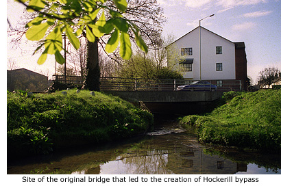
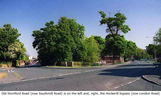
 Apart from a short stretch of protective railings either side of London Road near its junction with South Mill Road, there is no other indication that a modern bridge crosses the River Stort at this point. In fact, in this now fairly unremarkable part of Bishop’s Stortford, there is nothing at all to denote the importance this area once held in the town’s and Hockerill’s history. Apart from a short stretch of protective railings either side of London Road near its junction with South Mill Road, there is no other indication that a modern bridge crosses the River Stort at this point. In fact, in this now fairly unremarkable part of Bishop’s Stortford, there is nothing at all to denote the importance this area once held in the town’s and Hockerill’s history.
At the Restoration in 1660, Charles II rejected the royal homes at Theobalds and Royston in favour of a move to Newmarket. Quite handy for a king who was already a frequent visitor to the horse races there, but to his displeasure the journey took him through Bishop’s Stortford. His dislike of the noisy and congested town with its noxious odours emitted from the market, maltings and tanneries, are well recorded.
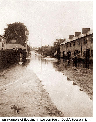
His agony was further compounded by the seasonal flooding that affected highways in this area, a fact recorded by another frequent passerby of Bishop's Stortford at that time; the diarist Samuel Pepys. He made the following entry in his diary on 23 May 1668: ‘and so to Bishop’s Stafford [sic]. The ways mighty full of water so as hardly to be passed’.
In 1666 the King's journeys through Bishop's Stortford became even more frequent after he bought Audley End, and Royal surveyor Andrew Lawrence was ordered to find a solution to the many problems associated with the route.
At around the same time a violent dispute ensued following the closure of the rickety Bridgegate at Southmill by the resident miller, Thomas Pryor, who pleaded a dearth of timber and resources to repair it. The Bridgegate crossed the original course of the river Stort at this point and linked to a track that led to Hockerill, which in times of flood was a public right of way. It was also where the two main roads either side of the valley came closest together.
During alteration work at Audley End to turn the house into a Royal palace, Andrew Lawrence saw a way of diffusing the situation in Stortford, as well as ingratiating the king. Surplus timber was used to rebuild the bridge at Southmill, and the route was further enhanced by strengthening the track at the junction of the roads to Hallingbury and Hockerill – now the junction where the railway bridge is sited. When he completed the work in 1670, Bishop’s Stortford’s very first bypass had been created and from then on most through traffic used the new route. It created untold wealth and fame for the inns of Hockerill (See Guide 9), but left the town sufferring a disastrous loss of trade.
By the end of the 17th century the bypass had helped make this road a principle route between London and Norwich (at that time one of the most populous citys in England), but the added attraction of the horse racing at Newmarket also made it a favourite haunt of Highwaymen eager to relieve punters of their winnings on their return to London. In a later period the notorious highwayman Dick Turpin is also said to have plied his trade in this area, and even stayed at Hockerill (See Guide 9).
Charles II was never troubled by highwaymen, but his love of the Newmarket races did very nearly prove fatal for him. In April 1683 a group of extreme Whigs plotted to assassinate him on his return from the races, but as luck would have it a fire at the racecourse led to the meeting being abandoned and he returned to London earlier than expected. In the event the plot came to nothing, but the attempt on the King’s life did result in the arrest and deaths of Lords Essex, Algernon Sydney, William Russell, and one Richard Rumbold who was hung drawn and quartered – one quarter of which was exhibited in Bishop’s Stortford as an example and a warning to others.
|
|
The Roman occupation of Britain lasted almost 400 years and resulted in the building of many fine roads, all of which rapidly fell into disrepair and decay when the Romans left and remained so for the next 1400 years.
During the Saxon and Medieval periods there wasn’t a need for ‘quality’ roads, simply because the majority of people travelled everywhere by foot or by packhorse along basic tracks. If a track became unusable they just created another one. It is the combination of these ‘people’ tracks, linking hamlets, villages and farms, and the ancient Roman routes between towns and cities that form the established road patterns we know today.
However, by the 16th century ‘roads’ were in a terrible state of disrepair nationwide – more especially the main arteries leading into London – and as a consequence the 1552 Road Act came into being. This required that every parishioner should give four (later six) days free labour each year for the repair of local roads, and that tenants paying more than £50 rent per annum should provide a team of horses and cart to assist in the service.
The work was to be supervised by an unpaid and unskilled ‘surveyor’ appointed by the parish Vestry, whose only pre-requisite was to have been in charge of a road gang for a period of one year. This compulsory labour by an unskilled work force, totally ignorant of effective road building techniques, was inefficient and spasmodic. Combined with the fact that locals were reluctant to improve roads used by travellers who had no responsibility for them, meant that most remained in a permanent state of bad repair.
The London to Bishop’s Stortford road was among them, although the problem in the Stort Valley wasn't helped by the terrain. With no stone to bind the earth together and springs constantly breaking through the ground, sand and gravel were washed away from the surface and the resulting clay was soon turned into a quagmire. Some holes in the road were said to be so deep that a man or packhorse could drown in one.
Wear and tear to highways and byways was exacerbated in the 16th century by a significant increase in both population and road traffic. As a consequence, the Essex Easter Sessions of 1602 ruled that the heavy drugges (carts) used to carry malt to London – at times weighing as much as 6 tons and pulled by teams of up to eight horses – should be taken off the roads between October and March, and that all heavy loads should, in winter, be carried by packhorse. It was a ruling made with little foresight. There were no restrictions on any other traffic using the roads, and the cost of carrying malt by packhorse to London virtually crippled the town’s malting industry until the order was lifted in 1637.
Things didn't really improve until 1663 when the Turnpike Act (Toll roads) superceeded the ineffectual Highways Act of 1552, and road users themselves were made to pay for their repair and upkeep.
The very first turnpike, known then as the Great North Road, was the well-trodden route established by the Romans some 1600 years earlier and known today as Ermine Street or the A1. Although successful it was sixty-nine years before the second toll road was opened, and not until 1702 that the Act actually became fully established and Turnpike Trusts were set up. The original purpose of Trusts was to assist the parishes, but with merchants, farmers and landowners all now wanting better communications, the government made it easier to gain Acts of Parliament to build roads, and parish labour was replaced completely. Between 1702 and 1752, 418 new toll roads were completed.
Locally, responsibility for the highways was initially put in the care of the County Quarter Sessions, but it was a body that proved less than satisfactory for the task. In 1744, by Act of Parliament, the Essex and Hertfordshire Turnpike Trust was appointed to administer the busy 28 mile stretch of highway between Harlow Bush Common (the southern boundary of the parish of Harlow, Essex) and Stumps Cross (in the parish of Great Chesterford, Cambridgeshire) – Parliamentary approval being required for one authority that spanned two or more counties.
More commonly called the Hockerill Turnpike Trust, presumably because its members held their meetings at the Crown Inn, Hockerill, it comprised of local residents of social standing. But of these 94 trustees appointed only six or seven took direct responsibility for the roads. Their first meeting was held on 14 May 1744 and the first tollgate was erected shortly after at Spellbrook, the proceeds being put to good use in improving roads in that area. To the north of Bishop’s Stortford a second tollgate was set up at Ugly, although this was later positioned closer to the town at the junction of Birchanger Lane.
By 1784 post boys (See Guide 13) had been replaced by mail coaches, and in 1785 a mail coach service began to travel through Bishop’s Stortford en route to Newmarket, Bury St Edmunds and Norwich. An influential voice in the upkeep of roads at that time was the controller of mail coaches, and as the livelihood of the town was now much dependant on road traffic, highways were kept in a constant state of good repair.
Nationally, the development of roads and adequate repair technology in the early 19th century is associated with John Metcalf (1717–1810), Thomas Telford (1757–1834), and John Louden Macadam (1756–1836), the latter, between 1815 and 1836, revolutionising road construction by laying a base of compacted broken stone covered with a drainable surface. The improvement was considerable and once completed, new roads were said to have been ‘macadamised’. Depending on the season, the fastest stagecoaches took only four hours to reach Bishop’s Stortford from London.
 Further improvements were made between 1822 and 1852 when Sir James Macadam, son of John Macadam, became surveyor to the Hockerill Turnpike Trust. His work shortened the journey time between London and Bishop’s Stortford (32 miles) to just three hours. Further improvements were made between 1822 and 1852 when Sir James Macadam, son of John Macadam, became surveyor to the Hockerill Turnpike Trust. His work shortened the journey time between London and Bishop’s Stortford (32 miles) to just three hours.
By the 1830s the country had over 1,000 trusts and 20,000 miles of turnpikes but the Hockerill Trust, even though it was properly run, was rarely in profit. In fact, Maltsters’ use of the Stort Navigation, built in 1769, could have been disastrous but for a workable agreement that kept toll roads in use and the Trust solvent.
The Trust took care of the main highways but it was the Surveyor, appointed by the vestry, who was responsible for the maintenance of roads within the parish and for seeing to the drainage of the town – the sanitary arrangements of which were quite primitive until the late 19th century. The Surveyor was appointed by the vestry up until 1836, when it was then decided to appoint a paid surveyor at a cost of £40 per annum. This 'paid' appoinment continued until 1856, but when difficulties arose in the performance of certain duties relating to the job, a Board was formed that same year for the superintendance of highways within the parish, and for putting into effect any laws relating to the highways.
Known as the Highway Board and consisting of 13 members elected annually at the parish meeting, it subsequently took over the duties of the Surveyors and Lighting Inspectors. To a certain extent the Board was answerable to the Vestry, but on 27 September 1866 its members called a public meeting at which the Local Government Act was adopted and confirmed at a subsequent meeting. The parish Highway Board's last meeting took place on 29 January 1867.
By this time the days of the Hockerill Turnpike Trust were also numbered, as were all turnpike trusts throughout the land, made redundant by the advent and rapid expansion of the railway in the 1830s and 40s. Between 1865 and 1895 the whole system was wound up, the powers of the Hockerill Turnpike Trust terminating on 1 November 1870. Care and maintenance of roads then became the responsibility of the newly emergent local and county councils.
The Trust held one further meeting on 13 December 1870 at which its assets were distributed among the several parishes in Essex, the Hadham District Highway Board (for Sawbridgeworth and Thorley) and the Bishop's Stortford Local Board of Health, which assumed responsibility for the former turnpike road in their respective areas.
The only evidence that the Hockerill Trust ever existed in Bishop’s Stortford are two remaining milestones – statutory requirements – one in Rye Street (See Guide 7), the other in Stansted Road (See Guide 10). Their use was two-fold. Initially, only heavy goods wagons and carts that caused road damage were charged to use them, but Hertfordshire Justices were determined that ‘all’ through traffic should pay, and as a result the Hockerill Trust made it an offence to bypass tollgates by travelling over private land. Consequently, milestones, like the two mentioned, were introduced not only as mileage indicators but also as an incentive to travellers to keep to approved routes.
The advent of motorised transport in the early 20th century led to the establishment of the Ministry of Transport in 1919, and the classification of first-class A roads and second-class B roads. The route between London and Cambridge, via Bishop’s Stortford, became the A11, surviving as such until 1984 when the M11 motorway between London and Stumps Cross, Cambridgeshire was completed. The A11 was then re-designated the B1383.
The following is taken from the Trust's Administrative History:
At South Mill, three-quarters of a mile south of the centre of Bishop's Stortford, the turnpike road divided into two branches, one through the town by way of Southmill Road, South Street, Potter Street, North Street, Rye Street, Hazelend Road and Gipsy Lane to cross the River Stort near Palmers Water, while the other crossed the river at South Mill and proceeded through Hockerill and northwards to join the first branch at Palmers Water.
An Act of 1791 enabled the Trust to construct a new road [now Michaels Road] linking these branches one mile north of the centre of Bishop's Stortford and to abandon responsibility for the old road on the western side of the river northward from that point to Palmers Water. This reduced the length of the Trust's road by threequarters of a mile, but the loss was more than made up as a result of an Act of 1829 which authorised the construction of two new branches of road at Newport and Harlow, of which the latter, from Harlow Mill to the George Inn, was by far the more important.
These increased the Trust's mileage to twenty-eight and a half, of which four miles was accounted for by branch roads, but under the Act maintenance of part of the road in Bishop's Stortford was made the responsibility of the parish. Other diversions and improvements which did not require the sanction of Parliament were also undertaken, notably the construction of South Road, Bishop's Stortford, in 1834. The Trust successfully resisted an attempt made in 1852 to consolidate it with other turnpike roads in Essex, and retained its separate identity.
Note: Although toll roads are generally called Turnpike roads, the actual turnpike is not the road but the barrier or gate that barred passage until the toll was paid. The word ‘turnpike’ has now been replaced by the word ‘turnstile’.
|


