|
First called Barborslane, or Basebolayne, this is one of two lanes that run parallel with North Street – the other, to the east, being Water Lane. Both were back lanes of the Saxon settlement’s main thoroughfare – now North Street – that was lined with house-farms. Behind each of these ‘farms’ were yards called ‘tofts’, and running off of those yards into these back lanes were long strips of land called ‘crofts. This familiar layout is associated with all Saxon settlements.
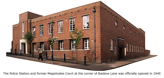
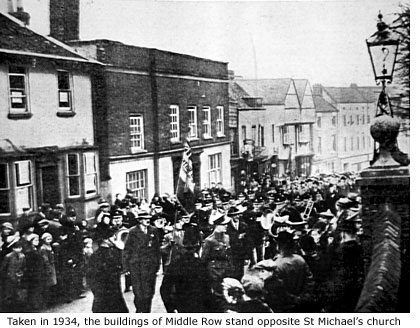 The Bull public house occupied the corner of Basbow Lane and High Street from 1677 to about 1810, and around 1850 the land on which it stood was sold at auction to a developer who built tenements and shops. These were known, collectively, as Middle Row, but by the late 1930s the buildings had become so run-down that the entire site was cleared to make way for the town’s new Police Station and Magistrates court, previously housed at Church Street (See Guide 15). The Bull public house occupied the corner of Basbow Lane and High Street from 1677 to about 1810, and around 1850 the land on which it stood was sold at auction to a developer who built tenements and shops. These were known, collectively, as Middle Row, but by the late 1930s the buildings had become so run-down that the entire site was cleared to make way for the town’s new Police Station and Magistrates court, previously housed at Church Street (See Guide 15).
Funded by Hertfordshire County Council to the tune of £25,000, it was officially opened on Friday 20 September 1940 by the Lord Lieutenant of the county, Viscount Hampden, though at that time only the court room had been furnished. Although typical of 1930s architecture, this building does seem a little out of place in this ancient part of town.
The Magistrates Court continued to administer justice in Bishop’s Stortford until 31 March 1998, but in that year financial cutbacks in legal administration forced its closure and townspeople, good or bad, have since had to travel to Cheshunt or Hertford to plead their case. In 1999/2000, over £1 million was spent on modernisation and refurbishment of the station, but less than a year after completion yet more financial savings within the Service made its new cells redundant. In a bid to ‘maximise resources’ it was decided the cells were under used and now all prisoners (currently [2004] averaging 800 per year) have to be transferred to Hertford’s police cells.
The car park alongside the police station was formerly Lucerne’s field, once used by locals to grow their own produce, and in the mid 1800s a large house that stood here, known as Fockinghams, was demolished by its then owner, G E Sworder.
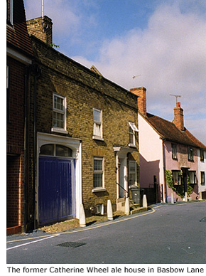
Deeds dating from 1890 to approximately 1944 refer to most properties here as being in Basbow Street instead Basbow Lane, though this was likely to have been a continual solicitor error. Number 35, a privately owned 17th century house, was, until 1780, the Catherine Wheel alehouse. Large wooden entrance gates to the left of the building once led to a cobbled yard and stables, but these have long since been lost to encroaching development.
Number 41 is grade II listed and was owned, briefly, in 1933 by an innkeeper named Charles John Woodford. This was probably the same Charles Woodford who owned the butcher's shop in Dane Street (See Guide 11 – Dane Street). Although deeds to this house reveal ownership back to 1744, it is thought to have been built in 1694.
 Adrian Gibson, the country's most respected authority on timber-framed buildings, lived at No 43 until his death in 2006. He received the MBE for services to conservation in 1993. A teacher of many subjects including woodwork, technical drawing, archaeology, architecture and the stone age, it was he who in 1956 unearthed a fragment of the ancient *Swanscombe skull, now kept in the Natural History Museum. Adrian Gibson, the country's most respected authority on timber-framed buildings, lived at No 43 until his death in 2006. He received the MBE for services to conservation in 1993. A teacher of many subjects including woodwork, technical drawing, archaeology, architecture and the stone age, it was he who in 1956 unearthed a fragment of the ancient *Swanscombe skull, now kept in the Natural History Museum.
He was a consultant for National Heritage, the Built Environment Advisory Services in Hertfordshire, and was involved in Hertfordshire Building Preservation Trust. Locally his archaelogical and architectural knowledge helped peice together the history of the 16th century barn at Thorley that is now the St Barnabas Centre (See Thorley).
Adrian Vernon Brough Gibson, born London 8 April 1931, was married in 1959 to Helen (nee Briggs) and had one son and one daughter. He died, aged 74, at Harlow, Essex 1 March 2006
At the far end of the lane is Steps Cottage, arguably the most unusual building in Bishop's Stortford. Triangular in shape and barely six feet wide at its narrowist point, this house appears to have been built to fit the small parcel of land at the bottom of the hill where Basbow Lane and King Street converge.
*Three perfectly matching pieces of the world famous 300,000 year-old 'Swanscombe Skull' were retrieved from Barnfield Pit in Swanscombe, Kent, in the the 1930s and 50s. They are amongst the oldest human remains ever discovered in Europe.
*Added information about properties in Basbow Lane are thanks to Spencer Thomas. MORE PICTURES
|



 The Bull public house occupied the corner of Basbow Lane and High Street from 1677 to about 1810, and around 1850 the land on which it stood was sold at auction to a developer who built tenements and shops. These were known, collectively, as Middle Row, but by the late 1930s the buildings had become so run-down that the entire site was cleared to make way for the town’s new Police Station and Magistrates court, previously housed at Church Street (See Guide 15).
 Adrian Gibson, the country's most respected authority on timber-framed buildings, lived at No 43 until his death in 2006. He received the MBE for services to conservation in 1993. A teacher of many subjects including woodwork, technical drawing, archaeology, architecture and the stone age, it was he who in 1956 unearthed a fragment of the ancient *Swanscombe skull, now kept in the Natural History Museum.
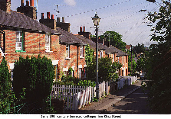
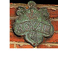 A flight of stone steps leads from Basbow Lane to the bottom of King Street, a steep hill leading back to Windhill and lined with early 19th century terraced cottages whose front gardens are mostly bordered by white picket fencing. High on the wall of numbers 25-33 can still be seen fire insurance company ‘firemarks’ – the ‘Royal’ insurance plates being an indication to fire fighters of the time that these houses were under that company’s cover. Two houses in Portland Road have similar ‘firemarks’, as does a property in (upper) South Street (See Guides 14 & 15).