|
|
|
 |
|
|
|
|
|
 |
|
|
|
 |
|
Guide map includes satellite image of this area
|
|

|
|
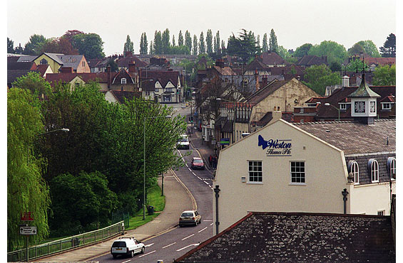
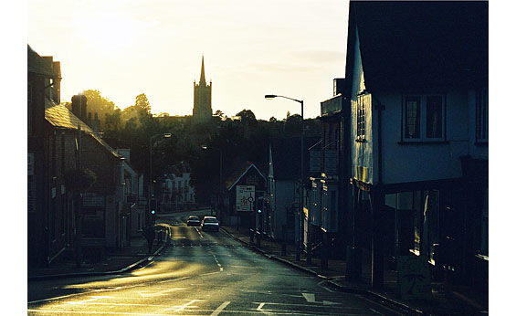
Separated from the town by the valley and the river running through it, Hockerill was once referred to as Bishop’s Stortford’s ‘hilltop outpost’. Its history, however, and that of the surrounding area east of the river Stort is just as fascinating as the town's and, in parts, goes back a lot further. No record exists as to what this area was first called, if indeed it had a name, but an early landowner here was Richard de Hockele, a capmaker in the 1270s. In the 14th century it was known as Hokerhull and in the 16th century as Hokers Hill. Further corruption of the name in the 17th century gave us present day, Hockerill.
A Romano-British settlement existed on high ground near to the Meads between the 1st and 5th century A.D., and under Norman rule Parsonage Manor was greatly extended - over 950 acres of land to the west and south becoming the Bishop's Park, primarily used for deer hunting. Parsonage Manor later became Rectory Manor, and in the 1950s the 17th century manor house formed part of the newly built Parsonage estate.
With the passing of the Poor Law Ammendment Bill in 1834 the old workhouse at Hockerill Street became the Union Workhouse. This was replaced in 1837 by a new, much larger Union Worhouse at Haymeads that in the 1900s became central to the building of Herts & Essex hospital. The Diocesan Training College for Schoolmistresses (now Hockerill Anglo-European College) opened at Dunmow Road in 1852, and towards the end of the 19th century Sir Walter Gilbey conceived Hockerill Park Estate, arguably one of the country’s first ‘Garden’ suburbs. In 1910 he also constructed the town’s golf course at Dunmow Road. To the north-west, at Parsonage Estate, ancient Birchhanger Woods has its roots firmly embedded in 10th century soil.
Hockerill became more prominent on the map in 1670 after Charles II, unknowingly, instigated the building of the Hockerill ‘bypass’ (See Guide 12). More and more travellers, including royalty, then used the new route between London and the towns and cities of East Anglia, and because of it the four inns at its crossroads gained fame and fortune. During the 18th century Hockerill’s wealth was said to be greater than the town itself. This led to the building of more shops and houses along Dunmow Road, London Road and Hockerill Street – development of the latter finally forging a tangible link with the town.
But with the arrival of the Railway in 1842, resulting in the demise of mail and stagecoach services that had made Hockerill so popular, its prosperity ended as abruptly as it had begun. By now, though, it was no longer a hilltop outpost and in 1852 a second parish church was established to cater for its ever-growing population (See Guide 10 - Stansted Road). MORE PICTURES
|
|
|
|
Hockerill Street
|
|
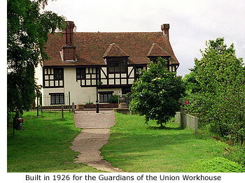 Hockerill Street starts at No 2 (Riverside House), a large, mock Tudor style property built in 1926 as headquarters for the Guardians of the Union Workhouse on the site of a former cottage and corn shop. Costing £2,750 to build, it comprised of three offices, a boardroom and waiting room. It was also shared at that time by both Hadham and Stansted Rural District Council, and between 1962 and 1994 was home to Bishop's Stortford Town Council. It is currently the town's Register office. Hockerill Street starts at No 2 (Riverside House), a large, mock Tudor style property built in 1926 as headquarters for the Guardians of the Union Workhouse on the site of a former cottage and corn shop. Costing £2,750 to build, it comprised of three offices, a boardroom and waiting room. It was also shared at that time by both Hadham and Stansted Rural District Council, and between 1962 and 1994 was home to Bishop's Stortford Town Council. It is currently the town's Register office.
The large clock that adorns the side of the building was rescued from a nearby riverside wharf before demolition early in the last century, and to the right of the building flowers now fill the horse trough that once stood outside No 11 North Street (See Guide 6 - North Street).
On the opposite side of the road is the entrance to the Meads, a recreation area of approximately 23 acres stretching from Causeway to Northgate End, and north as far as Michaels Road. It is also the town’s ancient flood plain. The Romans, during their occupation here, dug rubbish pits on this land (See Guide 7) and between the 1930s and 1960s the town council did exactly the same, using much of the area as a land-fill site. Unfortunately, an inadequate clean-up operation after tipping ended resulted in much of the rubbish resurfacing some years later. A plan is currently being considered to landscape the area.
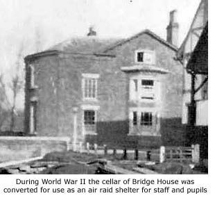 Near to the Meads entrance alongside the river once stood Bridge House, a large detached Georgian building that in 1929 was rented out by its then owner, Mr R.H. Cornell, to Waterside School after they moved out of Church Street Technical Institute (See Guide 15 – Church Street). Situated right on the water's edge it suited the school's name perfectly.
But as idyllic as this spot may have been for both teachers and pupils the house did lack dining facilities. Those children who had to stay for school lunch generally ate, as a group, in local restaurants. They were first catered for by a cafe in Dane Street then, later, by the more salubrious Long's Restaurant in North Street (See Guide 6). But by 1959 the lunchtime venue had changed yet again and each day a crocodile procession of children were led through the town to dine at the Swan Restaurant in South Street (See Guide 13). This daily event finally came to an end in 1963 when Bridge House was demolished to make way for the Causeway road-widening scheme, forcing Waterside school to move once again (See Guides 4 and 6).
The recreational area between the railway line and the river is named Sworder's Field in memory of past town resident, Herbert Sworder. One of three brothers, he was a member of the Sworder family who established themselves as the town's premier auctioneers in the 1800s. When Herbert died in 1933 he bequeathed to the town £450 to create a childrens' play area 'that would be central and accessible to all parts of the town'. It took a while, but his bequest was finally fulfilled eighteen years later when the town council finally chose this site for the play area. It was officially opened in August 1951. MORE PICTURES
|
|
|
|
 |
|
|
|
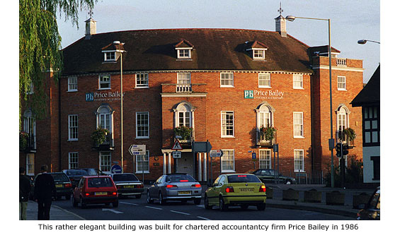
Adding a degree of elegance to this once rather run-down part of town is the large, neo-Georgian style building that stands on the north-east corner of Dane Street. Built in 1986 for chartered accountancy firm Price Bailey – established in the town since 1951 – its design shows a far more sympathetic attitude to the past adopted by architects and planners at that time.
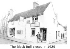 Between 1822 and 1920 this same site was home to the Black Bull public house, thought to have replaced another inn going by the same name that was demolished in 1569 for being a disorderly house. The daughters of Jack Ayliffe, one-time landlord of the more recent Black Bull Inn, reportedly worked at the George Hotel in North Street. Obviously the landlord there paid far better wages than their father! Between 1822 and 1920 this same site was home to the Black Bull public house, thought to have replaced another inn going by the same name that was demolished in 1569 for being a disorderly house. The daughters of Jack Ayliffe, one-time landlord of the more recent Black Bull Inn, reportedly worked at the George Hotel in North Street. Obviously the landlord there paid far better wages than their father!
Auction details of this property (HALS REF D/ETE B138) describe it as follows:
Brick and timber built tiled dwelling house.
3 sitting rooms and kitchen
4 bedrooms and cellar, cottage adjoining, 2up 2down
Yard: well, pump and stable
1921 occupied by former licensee A.J. Payne at £17 per annum. Property held for a term of 1000 years from 1663, at a peppercorn rent.
|
|
|
|
[ BACK TO TOP ] |
|
|
|
|
|
|
|
|
|


 Hockerill Street starts at No 2 (Riverside House), a large, mock Tudor style property built in 1926 as headquarters for the Guardians of the Union Workhouse on the site of a former cottage and corn shop. Costing £2,750 to build, it comprised of three offices, a boardroom and waiting room. It was also shared at that time by both Hadham and Stansted Rural District Council, and between 1962 and 1994 was home to Bishop's Stortford Town Council. It is currently the town's Register office.
 Near to the Meads entrance alongside the river once stood Bridge House, a large detached Georgian building that in 1929 was rented out by its then owner, Mr R.H. Cornell, to Waterside School after they moved out of Church Street Technical Institute (See Guide 15 – Church Street). Situated right on the water's edge it suited the school's name perfectly.
 Between 1822 and 1920 this same site was home to the Black Bull public house, thought to have replaced another inn going by the same name that was demolished in 1569 for being a disorderly house. The daughters of Jack Ayliffe, one-time landlord of the more recent Black Bull Inn, reportedly worked at the George Hotel in North Street. Obviously the landlord there paid far better wages than their father!