|
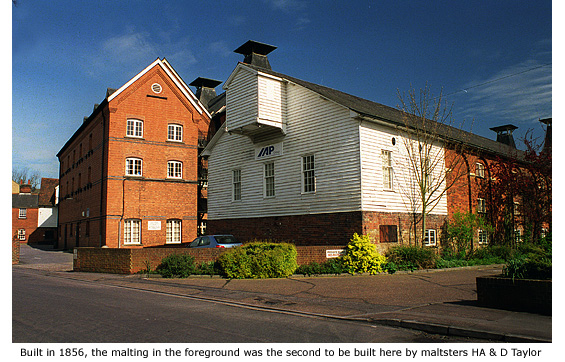
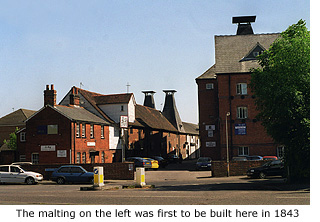
Filling the skyline behind Rhodes Centre, and standing on land once called South Street Field, are three of the finest remaining maltings left in the town, each erected at various times in the 19th century and all once owned by Messrs HA & D Taylor (See Guide 11).
The earliest and smallest of these malthouses, built in 1843 of brick and weatherboard with two slated cones, is currently part-occupied by a nightclub. The more substantial southern-most building, with arcaded brick walls and weatherboarding at the front, was built in 1856, and sitting between the two is the largest of the three maltings. Built of stock bricks with massive slate roof tiles, it was added in 1897. The buildings are officially known as Millar’s 1, 2 and 3, to commemorate the original maltser, Joshua Miller. (different spelling is correct!)
|
|
 During the Second World War, women helped with manual tasks in the maltings and American servicemen based at Stansted airbase regularly took away truck loads of ash for use as roads and paths. The maltings continued production until the mid 1900s.
In 1970 the Hertfordshire and Essex Malthouse Trust converted the buildings into The Triad arts centre and concert hall, but with support difficult to maintain they were later sold to a developer who adapted them for mixed usage that now includes light industry and leisure facilities. Between 1979 and 1998 the centre was home to the SNAP Theatre Company (National Educational Touring Theatre), founded by Andy Graham.
|
|
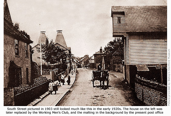
South Street continues through the town centre to where it joins Potter Street at the junction with Church Street. Because it would be confusing to note the history on either side of this road, this section only covers South Street between this point and Station Road; starting with the East side.
For most of its length South Street runs parallel with the river Stort. In the 18th and 19th century it was this easy access to the river and its barge transport that led to the building of many maltings and warehouses here. These, along with much of old Stortford in this area have long since disappeared, but many of the place names along the way are associated with the working river and prominent people from the town’s past.
 The first example of this is Braziers Quay, a modern residential development built in the 1990s that takes its name from the original quay named after Joe Brazier (See Guide 6 - Chequers Hotel). This was also the site of the Hat factory, demolished the early 1900s. A few Victorian terraced houses still survive in Wharf Road, but beyond is the modern development of Duckett’s Wharf, built on land and a wharf originally named after Sir George Duckett (formerly Sir George Jackson), co founder of the Stort Navigation (See Guide 11). The first example of this is Braziers Quay, a modern residential development built in the 1990s that takes its name from the original quay named after Joe Brazier (See Guide 6 - Chequers Hotel). This was also the site of the Hat factory, demolished the early 1900s. A few Victorian terraced houses still survive in Wharf Road, but beyond is the modern development of Duckett’s Wharf, built on land and a wharf originally named after Sir George Duckett (formerly Sir George Jackson), co founder of the Stort Navigation (See Guide 11).
Since the early 1990s, National Tyres has occupied the town’s former bus garage built in 1921 by Eastern National – just one of many private companies that came into being after the First World War to serve this area with passenger transport. After gaining control of the smaller companies, Eastern National began the first regular long distance bus route between Bishop’s Stortford and Epping in 1926.
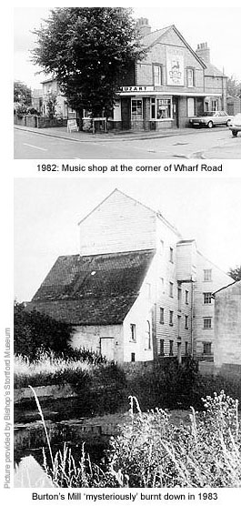
The premises of KwikFit is built on the former site of Burtons Mill; a 19th century five-storey high, timber-clad malting that once dominated South Street's skyline. Although it survived town redevelopment in the 1970s, its age and general condition left little doubt it would eventually be demolished. That expense was spared in 1983 when a 'mysterious' fire razed it to the ground.
Modern development now covers the land between this point and the Victorian house that is No 77 South Street, but in the early 1800s this area was commonly known as Phipp's Yard, owned by brewer and beer retailer, Thomas Phipp. In 1814, John Phipp, 1738–1818, (possibly Thomas's father) was granted a licence to hold the first Baptist meeting in Bishop's Stortford in his own home, but shortly after a barn at Phipp's Yard was hired for use as a chapel until 1819 (See Guide 14 – The Baptist Church).
Born in Ware, Thomas Phipp married Sarah Miller in St Michael's church on 20 April 1792, and between them they had at least eight children, all born in Bishop's Stortford. His business made him a wealthy man and it seems likely that one son, Thomas Phipp jnr, probably ran the business for his father or was handed it when Thomas snr moved to Warren Lodge, Mildenhall, Suffolk. There he became a Warrener and died in 1854. By coincidence, or not, it was about this same time that Thomas jnr's involvement in Phipp's Yard ceased.
*Additional information regarding the Phipp family is courtesy of Thomas Phipp jnr's great, great, great, grandaughter, Shirley Lawrence.
Adjacent to No 77 stands a large featureless building housing three shops, one of which was once the renowned Baxters fish shop. Long before Take-away restaurants invaded Bishop’s Stortford, this was the town’s only fish & chip shop and the place to go for a Friday night supper. Baxters retired from business in the 1990s but the premises still trade as a fish & chip shop – albeit greatly modernised.
An opening between this building and the next (a car sales showroom that defies any architectural merit or further comment) once led to Swan Yard and Swan Wharf – later to become Philip Churche's coal depot. An opening on the other side of this building gave access to Newman’s Ferryboat crossing that operated in the 19th century (See Guide 11).
|
|
At that time this area was better known as Catherine Wheel Alley and was a popular haunt of men who worked the river, known as bargees. Small timber clad buildings from that era still stand at the start of the alley. In the 1990s, modern utilitarian structures housing shops and businesses were built in the yard here and given the 21st century title of 'South Road Trading Centre.' They generated little trade though and the site closed in 2006. Housing development is now proposed for the area
As commercialisation in the town increased early last century, many private houses were converted for use as shops. Two such examples can be found here; their ground floors converted to form not only shops but also a ‘colonnade’, of sorts, giving more space to pavement and pedestrians.
Adjoining these shops, and filling the entire corner at South Street's junction with Station Road, is yet another example of 1950s architecture at its lowest ebb. Currently occupied by two restaurants, it was built in 1958 by the Co-operative Society and named, not surprisingly, Co-operative House. The Co-op had maintained a presence in the town since the late 1800s, but this department store on two floors was a radical move for them. Unfortunately, changing times led to a downturn in business and in the early 1980s the Co-op departed the town for good.
Long before that, houses had stood here and before that it was the site of the Catherine Wheel public house, demolished in 1870. Nearby Catherine Wheel Yard no doubt took its name from the pub.
|