|
|
|
 |
|
|
|
|
|
|
|
Rye Street
|
|
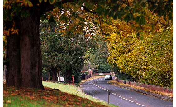
The 17th century Hertfordshire historian Henry Chauncy referred to this road as the North Road, though it was more generally known locally as the Manuden Road. It had in fact been designated Rye Street since the 13th century, the reason being that rye grass, valuable for pasture, grew in abundance on the uplands in this part.
Early maps describe the land between the road and the river as recreation ground but it was also once paddocks, owned by Sir John Barker who lived at The Grange. Before housing development took place in the 1960s and early 70s, the long terrace of Victorian cottages on Rye Street’s western side had enjoyed uninterrupted views across the Meads. MORE PICTURES
|
|
|
|
Galloway Road
|
|
In the early 17th century Galloway Road was referred to as Galloway Street, Gallows Street and Gallows Hill, and though the latter name suggests a somewhat macabre history, no record exists of anyone ever being hanged here. It is more likely that 'Galloway' or Gallow was the surname of a local resident. A narrow lane, it is also a section of the Roman road Stane Street, and in the 19th century was the site of a Brickworks – hence the naming of Brick Court, a modern residential property sited halfway up this steep hill.
No 87 Rye Street
In the late 1800s when Bishop's Stortford was still a market town, number 87 Rye Street was home to one of the most important persons in the area – namely the vet. Veterinary Practices were often sited on a main on the outskirts of a town, generally with an attached blacksmiths forge to better serve the needs of dray and coach horses.
Earliest records indicate that a Mr Brunskill MRCVS practised here in 1886, shortly after qualifying from the Royal Veterinary College in London. He also practised in Puckeridge but died at a young age in 1901. The practice was then sold to Ramsey Millar.
During World War I mules from the Remount Core were brought to Mr Millar at Rye Street for branding before being transported to the continent. The brand mark, an inverted ‘crows claw’, was applied to a mules foot so that in the event of its death the cavalryman could cut off the foot and return it to his superiors as proof he hadn't sold the animal. Part of the original stable here still carries the brand mark where it was tested before being used on mules.
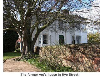 Between the wars Mr Millar kept saddle bags containing medicine by the range in his kitchen in case he had to make a night call to a local farm. If summoned he would then saddle-up his hunter mare and ride across the fields, finding it quicker than travelling by car.
He continued with the practice until just before the Second World War, then handed it on to his two sons. They were joined in September 1939 by newly graduated Lionel Wakley. He took over the practice after the war and was joined shortly after by Joe Paterson and Henry Mills. Wakley worked continuously from Rye Street for 42 years until his retirement.
Number 87 is now privately owned but the original purpose built stables and animal facilities, to the rear and side of the house, now form a modern Veterinary Hospital at the corner of Lindsey Road. This is currently one of about 200 such practices in Britain granted 'Hospital Status’. All vets who have ever worked at the practice, past and present, have been VetinarySurgeons.
There was another Veterinary practice in Stortford in the early 1900s, at the foot of Bells Hill next to the Bricklayers Arms public house. But this was run by a Veterinary Practioner who was restricted in what he could do and prescribe, having only served a form of apprenticeship, probably in the army.MORE PICTURES
|
|
|
|
|
Rye Street Milepost
|
|
|
|
|
|
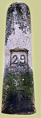 Directly opposite Galloway Road stands a large *milestone – one of only two that remain in Bishop’s Stortford, erected by the Hockerill Turnpike Trust between 1744 and 1869 (See Guide 12). Directly opposite Galloway Road stands a large *milestone – one of only two that remain in Bishop’s Stortford, erected by the Hockerill Turnpike Trust between 1744 and 1869 (See Guide 12).
This one, with the number 29 etched into it denoting the number of miles to London, marked the original route of the Hockerill Turnpike. When the Turnpike Trust changed the route to go around the town instead of through it, a similar milestone was erected in Stansted Road (See Guide 10)
This change of route naturally affected the accurate distance between the Cambridgeshire border and London – originally measured from the top of Whitehall (1744) but later from Shoreditch – and many milestones along the way had to be moved to correct this. The route was further shortened in 1777 when a new road was constructed between Harlow and the Hertfordshire border south of Sawbridgeworth, and the Epping New Road was built through Epping Forest.
Milestones were first introduced by the Romans to record distances between settlements, and re-introduced in the 17th century when Charles II established a national postal system. Distances between towns had to be recorded in order to know how much money to charge for letters, and this brought about the establishment of the Standard English mile.
*A road widening scheme carried out in Rye Street during 2005, involved temporary removal of the milestone. When replaced, workmen mistakenly erected it with the milage inscription facing oncoming traffic instead of the roadside.
|
|
|
|
|
|
|
|
|
|
|
Reynard Copse
|
|
 |
|
|
|
This small thoroughfare is relatively new to Rye Street, but its name keeps alive memories of the Fox public house which stood here for over 200 years before closure in 1993 and inevitable demolition in 1995. The premises apparently formed part of the marriage settlement of Godfrey Lee Farrant and Margaret Manesty in 1776. In 1814 it was held by John and Hannah Clark. Three burials are recorded from the house in that year, another in 1816 and one in 1817. The building was bought by local brewers Hawkes & Co in 1874.
Like all pubs and inns in the 19th century, the local Temperance Society did not favour the Fox. They published a poem in 1843 – probably written to celebrate the opening of a Temperance meeting place (See Guides 10 & 15) – that included the following verse:
There’s the jolly old PLOUGH where there is often a row
Where the drunkard’s get plenty of knocks:
Though out of town, it must still come down,
And so must the crafty old FOX.
Needless to say, neither the poem nor the Temperance Society had any effect on trade and the Fox remained a popular pub with locals. In its final years it was a rather ‘lively’ meeting place for members of Bishop’s Stortford Rugby Club. MORE PICTURES
|
|
|
|
Rye Street Hospital
|
|
 |
|
|
|
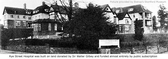
On the hill dominating the corner of Rye Street and Lindsey Road stands a large apartments complex called Cedar Court, a conversion of the original building that was Rye Street Hospital.
In 1892, Bartle John Laurie Frere – owner of Twyford House (See Thorley) – became aware of a particular case, whereby a person who was ill was unable to be cared for by necessary equipment in the town and had to travel to Cambridge for medical care.
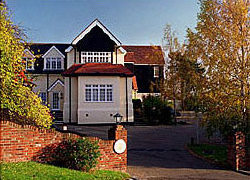 This incident inspired Frere to want to build a hospital for the people of Bishop’s Stortford, but he died the following year before anything could be started. His son, Laurie, and daughter, Margaret, then took up the cause and after a public meeting in the Great Hall at South Street (See Guide 15), a resolution was passed to build a hospital for the town, funded by voluntary donations. This incident inspired Frere to want to build a hospital for the people of Bishop’s Stortford, but he died the following year before anything could be started. His son, Laurie, and daughter, Margaret, then took up the cause and after a public meeting in the Great Hall at South Street (See Guide 15), a resolution was passed to build a hospital for the town, funded by voluntary donations.
Sir Walter Gilbey gave Land and the cost of construction was met by Mrs Frere and her family. The resulting two-storey building, with 9 beds and an operating room furnished by public subscription, was opened on 26 January 1895 by the Bishop of St Albans, and named the Frere Memorial Hospital. Nine days later the first patient was admitted, followed by a further 31 patients that same year.
In 1898, Sir John Barker donated money for a new General ward and the original staff of two was increased to four – a Matron, a staff nurse, a nurse and a probationer. A large donation in 1912 allowed a further wing to be built and in 1920 a gift of X-ray equipment was made usable with the help of local businessmen, Alfred Slapps Barrett and Herbert Sworder, who supplied the means for electricity to run it.
Many generous private gifts and donations were made through the years, with extra funds coming from public subscription and collection boxes located throughout the town. In 1925 a childrens ward was built and a lift installed, and by 1927 there were 32 beds. But with the town’s growing population, demand for admission became acute and it soon became obvious the hospital would have to be extended. In the following years a nurse’s home was built on the site, additions were made to the original structure and, finally, a new wing added in 1932 giving the hospital a total of 61 beds. The new wing was opened on 18 May 1933 by the Duchess of York (Queen Elizabeth the Queen Mother: 1901–2002).
In one year, some 50 years after it opened, the hospital handled 1,137 patients but was eventually absorbed into the National Health Service. Government cost-cutting in the 1970s led to its closure in November 1979, and in January the following year it gave temporary accommodation to Vietnamese Boat people – refugees of the Vietnam War in East Asia. They stayed for two years. In 1983 the entire site was sold to a local property developer for £535.000 and converted soon after into private apartments.
The name of one of its original benefactors lives on as Frere Court, Sheltered accommodation situated at the rear of Cedar Court, accessed via Pinelands.
MORE PICTURES
|
|
|
|
[ BACK TO TOP ] |
|
|
|
|
|
|
|
|
|



 Directly opposite Galloway Road stands a large *milestone – one of only two that remain in Bishop’s Stortford, erected by the Hockerill Turnpike Trust between 1744 and 1869 (See Guide 12).
 This incident inspired Frere to want to build a hospital for the people of Bishop’s Stortford, but he died the following year before anything could be started. His son, Laurie, and daughter, Margaret, then took up the cause and after a public meeting in the Great Hall at South Street (See Guide 15), a resolution was passed to build a hospital for the town, funded by voluntary donations.