|
There are visual clues in the lie of the land as to the provenance of the name ‘Bishop’s Stortford’. The bottom of Bridge Street sits between two hills where, for centuries, the river flowing through this valley from its source in Langley Hills, Essex created a wide flood plain. The resulting marshland was virtually impassable but for a narrow causeway between the two hills, and it was this, combined with the fact that the river at this point was naturally wide and quite shallow, that made it an ideal crossing place or 'ford'.
The Saxons, who established themselves high above the flood plain in the area we now call North Street, would most certainly have controlled the ford and referred to its importance by naming the area 'Esterteferd'. The word 'ferd' or ford is self-explanatory but the origin of ‘esterte’ is a little obscure. The Old English word 'steort' is said to mean ‘tail of land’, and in this case may have referred to the way Bishop's Stortford juts into *Essex. But it could also have been the name of a local family or even that of the person who controlled access to the ford. In truth, we will never know.
Ownership of the manor in the 11th century by the bishop of London gave it its prefix, but in the course of time the name Esterteferd was corrupted to Stortford. The river, around which the town grew up, wasn't actually mentioned by name until the 16th century when mapmakers Saxton & Camden designated it the Stort – the river thereby taking its name from the town and not the reverse as is usually the case.
*Herfordshire did not exist until about the mid-tenth century, at which time the area to the east (now Essex) was part of the ancient kingdom of the East Saxons.
|
|
 Medieval Bishop's Stortford, like all small towns and villages of that period, was not a clean place in which to live – pavements were non-existent and roads were little more than dirt tracks that immediately turned to mud when it rained. This particular street was a main thoroughfare but also an open sewer, a ditch running down the centre of it carrying the waste of the town into the river at the foot of the hill. Medieval Bishop's Stortford, like all small towns and villages of that period, was not a clean place in which to live – pavements were non-existent and roads were little more than dirt tracks that immediately turned to mud when it rained. This particular street was a main thoroughfare but also an open sewer, a ditch running down the centre of it carrying the waste of the town into the river at the foot of the hill.
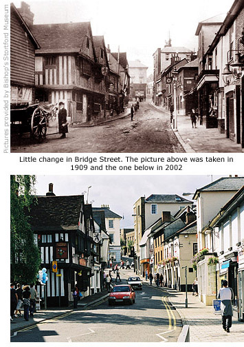
Present day Bridge Street was originally a continuation of High Street – the short section of road beyond the crossroads at the top of the hill – and wasn't named as such until a proper river crossing was established, probably in the 1760s when the Stort Navigation was built and this part of the river was banked and contained.
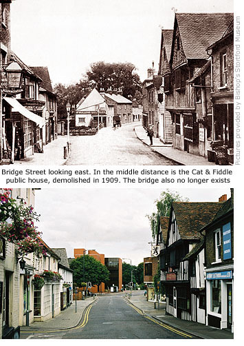
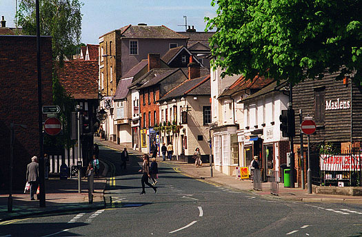
The question to be asked now is: where is the bridge from which the street takes its name and, more importantly, what happened to the river? Their disappearance is due to the Town Redevelopment Scheme of 1969, when the river was diverted away from the town centre to accommodate the Jackson Square development. But two clues remain that give testimony to their former presence, the first of which can be found in the road named 'Old River Lane' that leads to Causeway car park. This was the river's original course before it was filled in. The clue as to the whereabouts of the bridge is not quite so obvious but near to where the pedestrian crossing is sited, a slight hump in the road indicates the under lying structure that was left in place when Bridge Street was reconstructed.
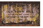
The river was one of the most important reasons why the Saxons chose to settle here and it wasn't long before they utilised its power  by building a water mill. At the time of Domesday Book (1086) a town mill was duly recorded, but for how long it survived after this date is unknown. What is known, though, is that some form of water mill was in place here for nearly a thousand years, the last one ending its production of flour in 1890 and demolished in 1895. Low on the wall alongside the entrance to Jackson Square, a small stone plaque indicates its former presence and states that the land on which it stood was donated to the town in 1911 by its then owner, Sir Walter Gilbey. by building a water mill. At the time of Domesday Book (1086) a town mill was duly recorded, but for how long it survived after this date is unknown. What is known, though, is that some form of water mill was in place here for nearly a thousand years, the last one ending its production of flour in 1890 and demolished in 1895. Low on the wall alongside the entrance to Jackson Square, a small stone plaque indicates its former presence and states that the land on which it stood was donated to the town in 1911 by its then owner, Sir Walter Gilbey.
The Jackson Square development, completed in 1974, is totally out of character with this area's architectural heritage but is typical of local planning and development at that time. Pedestrian access to it from Bridge Street was originally via a spiral concrete ramp way, but refurbishment of the shopping centre in 1991 replaced this with a lift and an escalator housed within the present glass structure, itself designed to represent the former mill.
A far better view of the river Stort’s former course can be had from the first floor of Jackson Square's entrance that overlooks Cooper's yard and Old River Lane. The section of water here was called, appropriately enough, Millstream and it was at this point that its current gathered pace as it was funnelled beneath the bridge to create the force needed to drive the mill wheel. The Victorian cottage seen at the far end of Cooper's yard originally sat right on the water's edge.
Another victim of the Jackson Square development was the Shades public house, built of brick in the early 1900s to replace a 16th century timber-frame inn of the same name that stood on the same site. Its unusual title, unknown anywhere else in Hertfordshire and Essex, was probably a reference to the 'shade' offered by large elm trees that once lined the Causeway. The original inn also stood alongside the water mill for nearly 400 years and no doubt provided countless pints of ale to settle dust in the throats of generations of millers. Refreshment of a purer kind was available for horses from the mill pool behind the pub. In the early years of the 20th century, when the circus paid its annual visit to the town, locals were treated to the sight of elephants drinking and bathing in the same pool.
 The Shades was bought by Truman's brewery in 1957 but finally closed for business on 29 August 1972. It was demolished shortly after.
On a part of the site now occupied by the District Council offices had once stood another pub, built in 1769 alongside the river and adjoined, on the Causeway side, by a terrace of houses called Castle Cottages. It was erected around the same time that the Stort Navigation was completed and first called the New Found Cut, the name probably a reference to construction of the Navigation Head at nearby Hockerill Cut (See Guide 8). However, at the time of the Crimean War in the 1850s, fervent patriotism was sweeping the land and scores of pubs, including this one, were renamed the Volunteer. For how long its new title lasted isn't recorded, but at the time of the pubs closure in 1909 it was called the Cat and Fiddle. Demolition followed soon after and a local chimney sweep, named Mr Shorter, built a house on the vacant site. MORE PICTURES
Read what life was like in the Causeway in the early 1900s - Guide 8 on the Memories page
|


