|
 |
|
|
|
|
|
 |
|
|
|
 |
|
Guide map includes satellite mage of area
|
|
 |
|
Three of the earliest bells in the present ring of St Michael’s Church were cast in 1713 by a local bell founder named John Waylett. He also cast the tenor in 1730. A man of great skill he was commissioned to make bells for many churches in Essex and Hertfordshire and is said to have cast most of them close to the site for which they were intended. Local tradition has it that St Michael’s bells were cast on land in or near Bells Hill, hence its name.
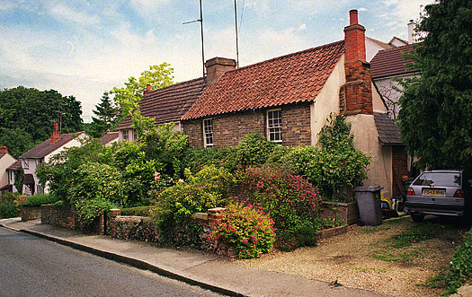
At the top of the hill is Regency Close, a small housing development built in the 1950s on land previously owned by the Royal British Legion. Two 19th century cottages (pictured above) stand just beyond the Close, the hill then dropping steeply towards Hadham Road with small houses from different periods on the right and Victorian terraced houses on the left. In 1921 one of these properties, then named 'The Chimes', was used as a boarding house for pupils of Bishop's Stortford College.
|
|
|
|
The Bricklayers Arms
|
|
|
|
 |
|
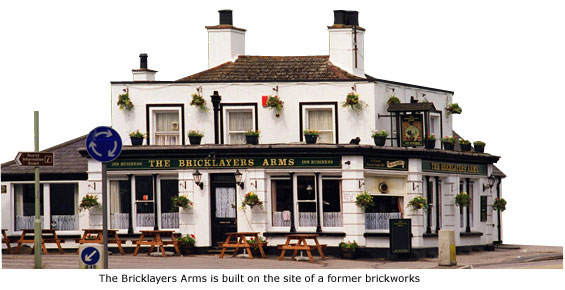
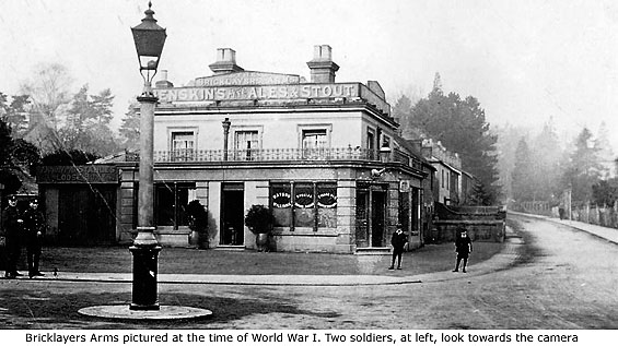
The entire history of this building isn't known but it wasn't here in 1839 and evidence suggests it was likely to have been a private house before it became a public house. Its name stems from the fact that it is built on the former site of a brick kiln and was probably associated  with either of two beer retailers known to exist in Hadham Road in1852 – John Boyten and John Hamilton. The pub was held by Mr W Jeeves in 1867 and then by Robert Brazier (1833–1898). Both his sons were born here – Joe in 1873 and Charles in 1876. with either of two beer retailers known to exist in Hadham Road in1852 – John Boyten and John Hamilton. The pub was held by Mr W Jeeves in 1867 and then by Robert Brazier (1833–1898). Both his sons were born here – Joe in 1873 and Charles in 1876.
Joe also became licensee of the pub in later years but is probably best remembered as landlord of the Chequers Hotel in North Street, a position he held for 44 years (See Guide 6 – The Chequers Hotel).
Hawkes Brewery enlarged the pub when they took it over in the mid to late 1800s, and in 1966 the interior was much modernised. Soon after this date it was threatened with demolition for yet another proposed road-widening scheme but, thankfully, the plan was abandoned. MORE PICTURES
|
|
|
|
|
|
Waytes Cross
|
|
 By the 17th century Bishop’s Stortford was established around four main roads that formed the shape of a cross, and on each of the four roads that led to the town centre stood a large stone, or wooden, cross informing travellers of its outer boundary. By the 17th century Bishop’s Stortford was established around four main roads that formed the shape of a cross, and on each of the four roads that led to the town centre stood a large stone, or wooden, cross informing travellers of its outer boundary.
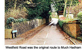
Waytes Cross, marking the town’s western approach, stood just beyond the Bricklayers Arms near to the junction of Maze Green Road and Westfield Road. Some local historians believe the word Wayte, or Waite, was derived from the fact that this road (Hadham Road) led directly to Waytemore Castle and was probably first called Wayte Street. It is more likely, however, that Waytes Cross took its name from fields on either side of Westfield Road that were collectively called Waitefield.
Westfield Road itself is a corruption of Waitefield and prior to 1836, when it is thought the present Hadham Road was constructed, it joined with Cricketfield Lane to form the ancient route to Little Hadham. Narrow and winding, Westfield Road now comes to an abrupt end behind the former site of the Grammar school (See Guide 3 – The Grammer School), its continuation to Cricketfield Lane lost long ago to housing development. MORE PICTURES
|
|
|
|
|
Roadside Crosses
|
|
|
|
|
|
In pre-Reformation times countless crosses were erected throughout England – all having religious significance but all serving different purposes. Some were classified as memorials, some as roadside crosses, and others as boundary markers or burial places. It was quite usual to hold executions at cross roads, the victims often buried nearby. Such crosses also acted as an alternative semi-hallowed place for felons and suicides barred from burial in consecrated ground. Other crosses were for preaching purposes, usually in churchyards, and market crosses were a visible symbol erected by the bishop of the diocese to signify that he had sanctioned it as a public market place.
Many crosses were named after a local place, trade, or person that may have lived in the immediate vicinity. This almost certainly applies to three of Bishop’s Stortford’s crosses but the fourth, once situated to the south of the town (See Guide 12 – Southmill Road), is thought to have been a boundary marker between Bishop’s Stortford and Thorley.
Most crosses throughout the country were taken down at the Reformation, and those that were not mostly disappeared at the time of the Commonwealth. No trace remains of Bishop’s Stortford’s crosses, although excavation work at Stansted Road in 1867 did reveal several medieval bricks that possibly formed part of the foundation of Collin’s Cross (See Guide 10 – Collins Cross). All four of the sites where crosses once stood around Bishop’s Stortford are now known by different names.
|
|
|
|
|
|
|
[ BACK TO TOP ] |
|
|
|
|
|
|
|
|


 with either of two beer retailers known to exist in Hadham Road in1852 – John Boyten and John Hamilton. The pub was held by Mr W Jeeves in 1867 and then by Robert Brazier (1833–1898). Both his sons were born here – Joe in 1873 and Charles in 1876.
 By the 17th century Bishop’s Stortford was established around four main roads that formed the shape of a cross, and on each of the four roads that led to the town centre stood a large stone, or wooden, cross informing travellers of its outer boundary.